Saturday 29 December 2012

Jeep Track and Ash Valley


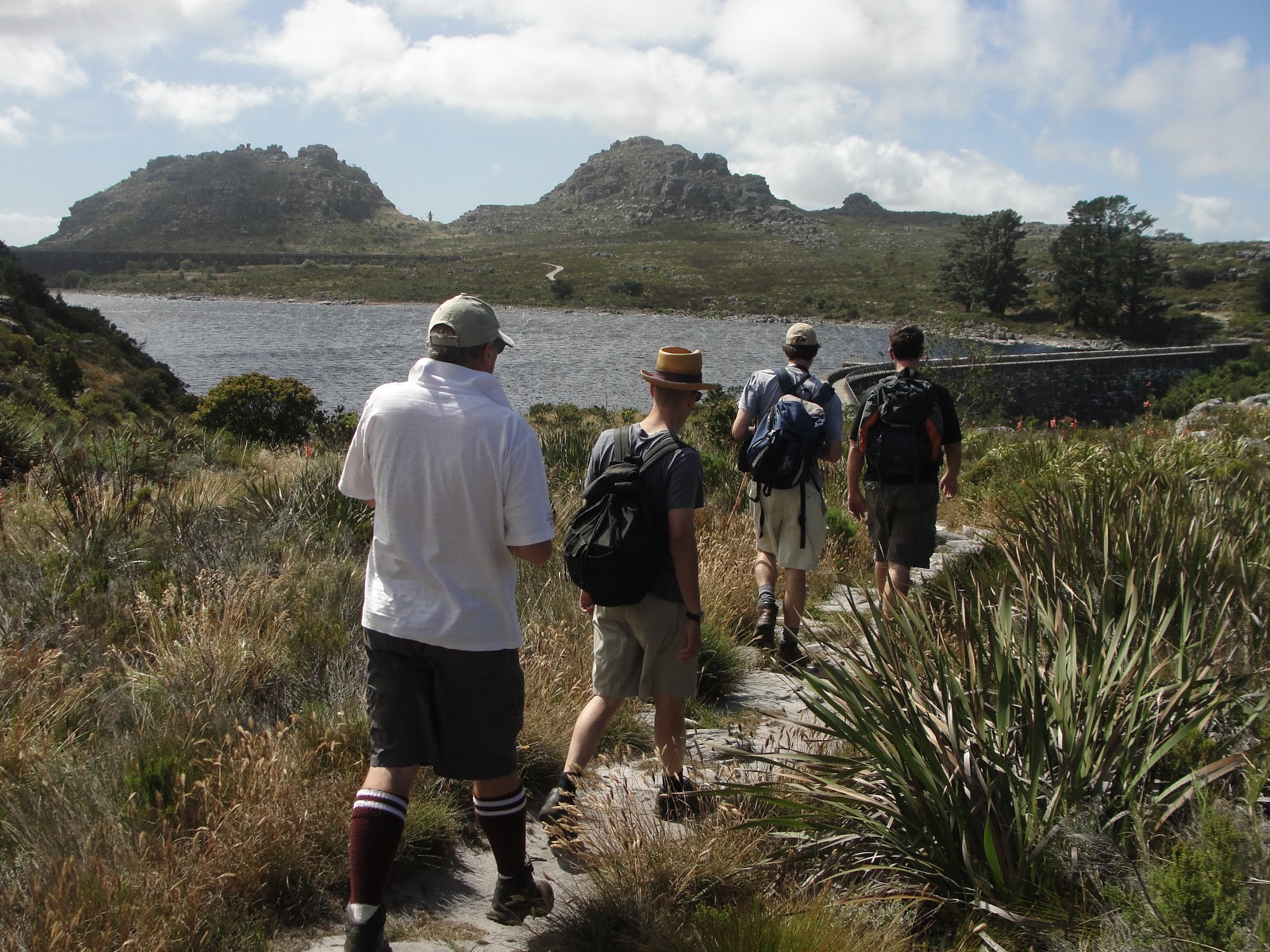
You know how it is in summer in Cape Town. Shortly after Christmas, someone says "let's go hiking!"  Personally I usually think "why now, when it's so hot?"  But I usually go along anyway, and always enjoy it. 

Yesterday's half-day hike was a day-tripper classic: up the jeep track to the dams, and down again in time for lunch. We started at 7:30 to miss the heat, but it was still pretty hot on the way up. I know there are many people who miss the shade of the pine forests, but I'm all in favour of fynbos and views instead, so I'm pleased that they're mostly gone.  The watsonias and pincushion proteas were out in force.

Once on top, we took a look at the dams.  One of our group is a water engineer who worked on the reinforcing of the century-old dams in the late 1990s, so we learnt a bit about the cables that were drilled into bedrock and post-tensioned.  It was good to see that the stainless steel railings they fitted along the walls are still looking shiny and new. A good investment. We also stopped at the waterworks museum, which was closed. Does anyone know when it opens? Do you have to arrange it in advance or what?

 For the route home, we took a detour off the jeep track near the top of Nursery, over into Ash Valley along a relatively indistinct path. In Ash Valley the path passes the hut once operated by the Scouts but now by the Western Province Mountain Club, and then meets a broader back that takes you back onto the jeep track at the Wynberg Overseer's hut, now part of the Hoeri Kwaggo Trail. The detour is no longer than the jeep track, but much more interesting. Shortly after the hut you can turn left off the jeep track again to follow a path that descends into Cecilia Forest, which I did earlier in the year, or stick to the jeep track back to the start.


Indicentally, although it was a pretty warm summer day in town, there was a strong breeze and a bit of a tablecloth that made it grey and quite chilly on top. When it's grey and windy around the dams, it always reminds me of Scotland and the lochs. It's always worth being ready for bad weather on top of Table Mountain. The jeep track may seem like a safe and easy route, but the level section on top is very exposed in bad weather.

We were down at the cars by 12 and unfortunately we were in a bit of a hurry or else we would have stayed for a pint at Constantia Nek restaurant. Make that two.  One for the left boot, and one for the right.

2012 in review

It's been a while: a long while since my last great blog post, and also quite a while since my last great hike. It's something to do with having a couple of kids who are too large and impatient for those put-the-kid-in-the-backpack devices, and too small and impatient for prolonged exertion.

2012 hasn't been completely barren hiking territory though. In January I joined the Scouts on a couple of one-day kloofing trips to Elandspad River and Bobbejaans River, a route from East Fort over Vlakkenberg to Constantia Nek that I hadn't done before, a short night hike to the King's Blockhouse, and a winter weekend in the Cederberg, with an icy trip to the Wolfberg Arch via the Cracks and a potentially life-threatening accident at Stadsaal Caves.

With friends, I did a couple of half-day hikes, including the Jeep track/Ash Valley/Cecilia circuit, which I'll blog about shortly.  I might fill in the gaps on the blog if I find a moment, but then again, I might not

Saturday 4 September 2010

Table Mountain - Some Easy Ways to the Summit (1913)

This is a guide book published in 1913, which I scanned, OCRed and converted to PDF... enjoy! It's an interesting read, not least to see how our use of English has changed, but also to see how the mountain has changed in some ways and stayed the same in others. Back then, there was no Tafelberg Road, so the Platteklip Gorge ascent started on Buitenkant Street. For the pipe track, you could take a tram from the city to Kloof Nek. For the Saddle, the path started at Forester's Arms. You know, all those times I've been to Forries, despite the name, it never once occurred to me that it used to be the gateway to Newlands Forest and the mountain. That was before De Waal Drive was built, of course.

Most of the routes described are still popular, but please don't head off onto the mountain following this guidebook as if it was still current. Over the past century, paths have come and gone, some ravines (Slangolie) have become largely impassable due to landslides, rights of access have changed (Orange Kloof), and our tolerance for risk (Blinkwater / Stinkwater) has also changed...

Table Mountain - Some Easy Ways to the Summit (1913)

Tuesday 10 August 2010

Mowbray Ridge and Minor Peak

Mowbray Ridge is one of my favourite hikes on Devils Peak, not least because I grew up in the shadow of Devil's Peak, and as a student it was one of the closest hikes from UCT. Most recently I've enjoyed it because you can fit a lot of scenery and serious ascent into an energetic half day, and still be back home to spend some quality time with the wife and kids. The last time I climbed Mowbray Ridge was a date I will not forget for two reasons, one of which, tragically, I blogged about at the time. But now it's time for an article about the hike that preceded that.

Mowbray Ridge is the northeastern corner of Devils Peak, and a very windswept corner it is too, especially when the Cape Doctor blows, which is most of the time on the ridge. The vegetation and outlook changes dramatically along a sharp line: lush and bushy on the eastern slope overlooking the Southern Suburbs and Cape Flats, and dry, frequently burnt and grassy overlooking the city and harbour on the north.


At the base of the ridge is Plumpudding Hill, a rounded grassy shale outcrop above Rhodes Memorial. For years there was a radar beacon there, a sort of technological memorial to three fighter jets that crashed into Devils Peak in low cloud in 1971. The radar beacon has gone but the trig beacon and view are still there.

Further up, at the base of the cliffs, is the King's Blockhouse, another beacon and a couple of cannons. It's the best preserved of the forts on Table Mountain, and is still used as a radio relay station, I think. The area between Rhodes Memorial and the Blockhouse is unfortunately a hotspot for mountain muggings, so be warned.

Behind the blockhouse the climb starts in earnest. It climbs and scrambles rapidly through various cracks in the purple sandstone to the right of the ridge, and soon reaches a magnificent viewpoint at an old fire lookout house, now abandoned. One of the great 270-degree views on Table Mountain.

The path continues up the ridge and climbs less steeply on an open slope. At one point you have the choice of going along the Upper Traverse contour path to the right, or heading straight up the ridge. The path to the right is better in heavy wind if you have a fear of heights: straight ahead, the knife edge ahead is not for the faint-hearted, as it overlooks a huge drop into the enormous First Waterfall Ravine on the left.


The knife edge descends slightly, then climbs again, ending in a short and steep scramble to Minor Peak, just above the nek at the top of First Waterfall Ravine. Really, with the sense of achievement you get at that point, it should have a more commanding name.

From Minor Peak, you have several options:
  • Descend to Upper Traverse, and continue down to Middle Traverse, then turn left and work your way back down on a series of descents back to the blockhouse.
  • Or descend to Upper Traverse, turn left, and continue onto the Saddle from which you can slog up the final slopes of Devil's Peak (and then down Newlands Ravine, perhaps).
  • Or, if you know the way (be warned: it is easy to get lost in very dangerous terrain on this route), take the frontal ascent to the top of Devil's Peak. Again, definitely not for anyone with a fear of heights.

Monday 7 June 2010

Wit Els 2001

While I'm on the subject of photos for Bruce... here are some photos a kloofing trip we did down the Wit Els, back in 2001. I can't quite believe it's been so long since I last went been down this magnificent river, but I'll be back one day.


Bottom hut


Middle hut


Pell's Hut, newly renovated


On the long descent from Waaihoek into the gorge.


Disa Falls, and Bruce trying unsuccessfully to get a GPS signal.


One of the swims, or perhaps one of the wades


Waterproofing the packs


Definitely one of the swims


And another


And another.


Me, at Alder Ring campsite


Dave


The gang, or most of them.

Wednesday 2 June 2010

Tafelberg, 10 years ago

Some photos from a winter hike up Tafelberg, 10 years ago, by popular request from Bruce...


The gang, The Spout, and my favourite peak.

Snow near The Spout, and me, Dave, Lynette, Bruce, Bruce, Bruce and Bruce. Photoshopping was harder in the days before digital.

Me, tied-dyed shirt, and Sneeberg across the valley.

Bruce looking down from the Spout. Remnants of snow around Consolation Peak.

Broken MSRs at Spout Cave

Ice at the overnight spot.

Dave

Lynette

Sunset from The Spout.

Wednesday 17 March 2010

Smuts Track: Skeleton Gorge to Maclears Beacon, and down Nursery Ravine

Smuts Track is one of the most popular hiking routes on Table Mountain. It's named after Jan Smuts, who was a keen outdoorsman and hiked this route energetically and regularly, well into his old age. Here's why I like the route.

Firstly, Skeleton Gorge. This is one of the most popular and most pleasant routes up Table Mountain. It leaves from Kirstenbosch, climbs through beautiful and shady indigenous forest, takes in a waterfall, includes a few wooden ladders and a scramble up a rocky stream bed, past a cave which is a perfect resting place, and finally emerges from the forest to give you a superb view over False Bay and the Southern Suburbs. It's not the easiest route, though: it's rocky and can be slippery near the top, and should be avoided in winter or after heavy rains, and like any direct ascent it can be challenging if you're not that fit.

Once you're at the top of Skeleton Gorge, follow Smuts as he takes a sharp right and starts a more gradual ascent from the Back Table towards Table Mountain itself. This is a superb route in its own right, with clifftop views, dramatic drops (and a detour to Carrell's Ledge if you're up to it), a ruined cottage if you have the Slingsby map, disas and watsonias in bloom at the right time of year, and bizarre rock formations.

Then the top. Maclears Beacon is the highest point on Table Mountain (1086m) and has fantastic 360 degree views over the entire peninsula on a clear day. The wind can whistle and the tablecloth can cover you at any moment though, so be prepared for a bit of chill, even in summer.

From the top, it's a flat but fairly lengthy walk to the Cable Station, or you can descend via Platteklip Gorge, which is a long zigzag staircase taking you down towards the City Bowl. A good, efficient descent if your knees are up to it, and a very popular ascent too, even if it is rather unrelenting and exposed in summer.

I prefer a longer return journey, which takes you back to Kirstenbosch. From Maclears Beacon, retrace your steps until you are about half way back to Skeleton Gorge. Then turn right and follow an old stone aqueduct, which takes you through a pleasant and secluded valley ending at Hely-Hutchison reservoir. Unexpectedly, at the century-old dam wall, there is a waterworks museum which is worth a visit.

Then the descent via Nursery Ravine. It's similar to Skeleton, with great views and pleasant indigenous forest, but it's steeper and less shady than Skeleton Gorge so I don't generally choose it as an ascent. As a descent, it is great, because it has fewer irregular rocky parts and is less slippery than Skeleton, especially in winter. It also gets you down quicker.