Showing posts with label routes. Show all posts

Saturday, 29 December 2012

Jeep Track and Ash Valley


You know how it is in summer in Cape Town. Shortly after Christmas, someone says "let's go hiking!"  Personally I usually think "why now, when it's so hot?"  But I usually go along anyway, and always enjoy it. 

Yesterday's half-day hike was a day-tripper classic: up the jeep track to the dams, and down again in time for lunch. We started at 7:30 to miss the heat, but it was still pretty hot on the way up. I know there are many people who miss the shade of the pine forests, but I'm all in favour of fynbos and views instead, so I'm pleased that they're mostly gone.  The watsonias and pincushion proteas were out in force.
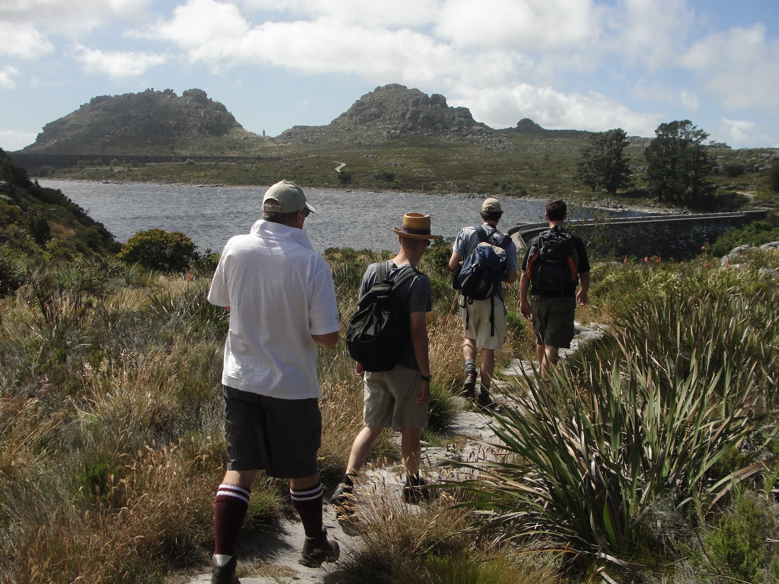
Once on top, we took a look at the dams.  One of our group is a water engineer who worked on the reinforcing of the century-old dams in the late 1990s, so we learnt a bit about the cables that were drilled into bedrock and post-tensioned.  It was good to see that the stainless steel railings they fitted along the walls are still looking shiny and new. A good investment. We also stopped at the waterworks museum, which was closed. Does anyone know when it opens? Do you have to arrange it in advance or what?

 For the route home, we took a detour off the jeep track near the top of Nursery, over into Ash Valley along a relatively indistinct path. In Ash Valley the path passes the hut once operated by the Scouts but now by the Western Province Mountain Club, and then meets a broader back that takes you back onto the jeep track at the Wynberg Overseer's hut, now part of the Hoeri Kwaggo Trail. The detour is no longer than the jeep track, but much more interesting. Shortly after the hut you can turn left off the jeep track again to follow a path that descends into Cecilia Forest, which I did earlier in the year, or stick to the jeep track back to the start.


Indicentally, although it was a pretty warm summer day in town, there was a strong breeze and a bit of a tablecloth that made it grey and quite chilly on top. When it's grey and windy around the dams, it always reminds me of Scotland and the lochs. It's always worth being ready for bad weather on top of Table Mountain. The jeep track may seem like a safe and easy route, but the level section on top is very exposed in bad weather.

We were down at the cars by 12 and unfortunately we were in a bit of a hurry or else we would have stayed for a pint at Constantia Nek restaurant. Make that two.  One for the left boot, and one for the right.

2012 in review

It's been a while: a long while since my last great blog post, and also quite a while since my last great hike. It's something to do with having a couple of kids who are too large and impatient for those put-the-kid-in-the-backpack devices, and too small and impatient for prolonged exertion.

2012 hasn't been completely barren hiking territory though. In January I joined the Scouts on a couple of one-day kloofing trips to Elandspad River and Bobbejaans River, a route from East Fort over Vlakkenberg to Constantia Nek that I hadn't done before, a short night hike to the King's Blockhouse, and a winter weekend in the Cederberg, with an icy trip to the Wolfberg Arch via the Cracks and a potentially life-threatening accident at Stadsaal Caves.

With friends, I did a couple of half-day hikes, including the Jeep track/Ash Valley/Cecilia circuit, which I'll blog about shortly.  I might fill in the gaps on the blog if I find a moment, but then again, I might not

Tuesday, 10 August 2010

Mowbray Ridge and Minor Peak

Mowbray Ridge is one of my favourite hikes on Devils Peak, not least because I grew up in the shadow of Devil's Peak, and as a student it was one of the closest hikes from UCT. Most recently I've enjoyed it because you can fit a lot of scenery and serious ascent into an energetic half day, and still be back home to spend some quality time with the wife and kids. The last time I climbed Mowbray Ridge was a date I will not forget for two reasons, one of which, tragically, I blogged about at the time. But now it's time for an article about the hike that preceded that.

Mowbray Ridge is the northeastern corner of Devils Peak, and a very windswept corner it is too, especially when the Cape Doctor blows, which is most of the time on the ridge. The vegetation and outlook changes dramatically along a sharp line: lush and bushy on the eastern slope overlooking the Southern Suburbs and Cape Flats, and dry, frequently burnt and grassy overlooking the city and harbour on the north.


At the base of the ridge is Plumpudding Hill, a rounded grassy shale outcrop above Rhodes Memorial. For years there was a radar beacon there, a sort of technological memorial to three fighter jets that crashed into Devils Peak in low cloud in 1971. The radar beacon has gone but the trig beacon and view are still there.

Further up, at the base of the cliffs, is the King's Blockhouse, another beacon and a couple of cannons. It's the best preserved of the forts on Table Mountain, and is still used as a radio relay station, I think. The area between Rhodes Memorial and the Blockhouse is unfortunately a hotspot for mountain muggings, so be warned.

Behind the blockhouse the climb starts in earnest. It climbs and scrambles rapidly through various cracks in the purple sandstone to the right of the ridge, and soon reaches a magnificent viewpoint at an old fire lookout house, now abandoned. One of the great 270-degree views on Table Mountain.

The path continues up the ridge and climbs less steeply on an open slope. At one point you have the choice of going along the Upper Traverse contour path to the right, or heading straight up the ridge. The path to the right is better in heavy wind if you have a fear of heights: straight ahead, the knife edge ahead is not for the faint-hearted, as it overlooks a huge drop into the enormous First Waterfall Ravine on the left.


The knife edge descends slightly, then climbs again, ending in a short and steep scramble to Minor Peak, just above the nek at the top of First Waterfall Ravine. Really, with the sense of achievement you get at that point, it should have a more commanding name.

From Minor Peak, you have several options:
  • Descend to Upper Traverse, and continue down to Middle Traverse, then turn left and work your way back down on a series of descents back to the blockhouse.
  • Or descend to Upper Traverse, turn left, and continue onto the Saddle from which you can slog up the final slopes of Devil's Peak (and then down Newlands Ravine, perhaps).
  • Or, if you know the way (be warned: it is easy to get lost in very dangerous terrain on this route), take the frontal ascent to the top of Devil's Peak. Again, definitely not for anyone with a fear of heights.

Wednesday, 17 March 2010

Smuts Track: Skeleton Gorge to Maclears Beacon, and down Nursery Ravine

Smuts Track is one of the most popular hiking routes on Table Mountain. It's named after Jan Smuts, who was a keen outdoorsman and hiked this route energetically and regularly, well into his old age. Here's why I like the route.

Firstly, Skeleton Gorge. This is one of the most popular and most pleasant routes up Table Mountain. It leaves from Kirstenbosch, climbs through beautiful and shady indigenous forest, takes in a waterfall, includes a few wooden ladders and a scramble up a rocky stream bed, past a cave which is a perfect resting place, and finally emerges from the forest to give you a superb view over False Bay and the Southern Suburbs. It's not the easiest route, though: it's rocky and can be slippery near the top, and should be avoided in winter or after heavy rains, and like any direct ascent it can be challenging if you're not that fit.

Once you're at the top of Skeleton Gorge, follow Smuts as he takes a sharp right and starts a more gradual ascent from the Back Table towards Table Mountain itself. This is a superb route in its own right, with clifftop views, dramatic drops (and a detour to Carrell's Ledge if you're up to it), a ruined cottage if you have the Slingsby map, disas and watsonias in bloom at the right time of year, and bizarre rock formations.

Then the top. Maclears Beacon is the highest point on Table Mountain (1086m) and has fantastic 360 degree views over the entire peninsula on a clear day. The wind can whistle and the tablecloth can cover you at any moment though, so be prepared for a bit of chill, even in summer.

From the top, it's a flat but fairly lengthy walk to the Cable Station, or you can descend via Platteklip Gorge, which is a long zigzag staircase taking you down towards the City Bowl. A good, efficient descent if your knees are up to it, and a very popular ascent too, even if it is rather unrelenting and exposed in summer.

I prefer a longer return journey, which takes you back to Kirstenbosch. From Maclears Beacon, retrace your steps until you are about half way back to Skeleton Gorge. Then turn right and follow an old stone aqueduct, which takes you through a pleasant and secluded valley ending at Hely-Hutchison reservoir. Unexpectedly, at the century-old dam wall, there is a waterworks museum which is worth a visit.

Then the descent via Nursery Ravine. It's similar to Skeleton, with great views and pleasant indigenous forest, but it's steeper and less shady than Skeleton Gorge so I don't generally choose it as an ascent. As a descent, it is great, because it has fewer irregular rocky parts and is less slippery than Skeleton, especially in winter. It also gets you down quicker.

Tuesday, 9 February 2010

The Jeep Track or Bridle Path

The Jeep Track or Bridle Path is the easiest route to the back table, i.e. the lower part of the range just south of Table Mountain. The route starts at Constantia Nek as a gravel road, and winds up the slopes above Cecilia Forest through what was until recently a commercial pine plantation and is now thankfully being allowed to return to the natural fynbos. Closer to the top, the road is concrete, with a few rock cuttings and a bridge. On the top, there is a fairly long stretch, more or less level, that passes the three smaller reservoirs and the former Wynberg overseer's hut (now part of the Hoeri Kwaggo Trail) and then ends at the Woodhead and Hely-Hutchison reservoirs.

Sunday, 7 February 2010

Carrell's Ledge

Carrell's Ledge is one of the poorly-kept secrets of Table Mountain. It's an absurdly unlikely traverse across the cliff face at the top of Ascension Buttress, overlooking the Pulpit and Newlands Forest, which is where you would land up if you missed your footing on your way across. There are some breathless accounts on the web about how it's "only 20cm wide" (slightly wider than the white line in the middle of a road), which is a bit of an exaggeration, but nonetheless it is a spectacular crossing.

There's a rather overgrown path, not marked on the recent maps, and the start is fairly hard to find, and this is really not somewhere you'd like to get lost. So please don't try it unless you know what you're doing, and don't even think of trying it in bad weather.

Monday, 7 December 2009

Gansbaai to Betty's Bay

Start at the Western end of Gansbaai, known as Die Kelders, and hike along the beach across Walker Bay towards the mouth of Hermanus Lagoon. This should take you till the evening, unless you made a really early start from Cape Town. You can either camp at a campsite or holiday house in Hermanus, or risk a large fine and unpleasant awakening by sleeping on the beach or the shores of the lagoon. Not really worth it. The next day, take the beach paths through Hermanus - a surprisingly long hike, with many welcome distractions of beaches and holiday life. You should be able to get past Onrus by the late afternoon - it's probably not such a good idea to trespass on the reserve at Hoek van die Berg, with the vearious perlemoen wars in this area. There is a campsite at Hawston. From Hawston, you again hit a long beach passing Bot River mouth and the lagoon and ending at Kleinmond.

Well, here my description of the hike ends because we hitched from Kleinmond to our next night stop at Palmiet river mouth (a short hike, anyway) and then got rained on. After trying to take shelter in some municipal restrooms we chickened out and hitched to Betty's Bay.

If anyone knows anything about beach routes anywhere along the South coast between Mossel Bay and Pringle Bay, please let me know. Or along False Bay from Muizenburg to Gordons Bay - It would be an epic hike from Muizenburg to Agulhas, and I'd like to hear more about the route.

Kouebokkeveld

The Kouebokkeveld mountains here are largely privately owned so access is pretty exclusive unless you know the right person or belong to the right hiking club.

The Olifants River Dome (1621m) is a spectacular peak which is very hard to get to, along a tortuous traverse and a huge descent and ascent just when you thought you were there. The summit log shows it was climbed in 1991 (for the MCSA centenary), and next by the SMC in 1994. The peak is an 8-hour round trip from base camp at the top of Naauwkloof (where a shepherd's hut provides shelter if not warmth for 3 to 4 people, or 15 in a storm), and from the farm Schoongezicht to the camp takes 2 hours.

Another nice peak with a spectacular nek is Driekoppe (1760m?). (Spectacular is a word which you will probably use often in the Kouebokkeveld.) Unlike the Dome, Driekoppe is an easy climb and is reached in about 2 hours hiking from the campsite and about one hour back down. You can see Table Mountain easily on a clear day and all the major peaks from Sneeuberg and Tafelberg to Groot Winterhoek.

Then somewhere out there is an old shepherd's cave which has been visited maybe two or three times in a few decades. It still has the original kettle, potjie and firewood supply, and a few tins of coffee. It also has some old bushman paintings, very faint, and a magnificent view. Well worth the slog through unmarked mountains, but only a few people know where it is, and it's not a location I would want to geocache or blog about!

Sunday, 6 December 2009

Devils Peak via First Waterfall Ravine


First Waterfall Ravine is a little-used climb up Devils Peak not marked on the new Mountain Club map, but the path has been in existence since the blockhouses were built at around the turn of the 19th Century. It is known as the 1000 Steps, which just about sums it up - quite a climb but with a very rewarding view from the nek at the top of the gorge. The gorge is reached from the Blockhouse above Rhodes Memorial: a path above the Contour Path skirts the mountain and enters the gorge. The ascent then begins in some indigenous forest, although there is a brief section out of the gorge to pass a waterfall. Towards the top the gorge is more open and very loose - tumbling rocks are a real danger and the party should stick close together. There are one or two rocky scrambles and the top section is very sandy and steep.

Once you have admired the view over the city bowl and Table Bay you can descend by Mowbray Ridge or take the frontal ascent to Devils Peak itself - best attempted with someone who knows the route.

Not to be confused with Second Waterfall Ravine, which is impassable and has claimed the lives of many unwary hikers.

Kleinmond / Koggelberg area

Another one sent by a reader, who I have since lost touch with:

"We live on a plateau on the top of the Kogelberg mountains behind Kleinmond. It's the only farm on the mountain and surrounded by state forest and adjacent to the Kogelberg Biosphere. A truly beautiful place with vineyards, apples and pears. We have a 15ha dam stocked with telapia and a couple of houses on the farm. The farm is overlooking the Elgin valley to the north and about 7km from the beach between Kleinmond and the Botriver lagoon to the south. Some of the existing hiking trails go past our farm, but are seldomly used, and we've always thought it a good idea to have hikers over for a night or two on their way to Betty's Bay, Kleinmond or Gordons Bay. Would like to hear from you."

Rosa
24 September 2000

De Hoop Whale Hiking Trail

This was sent to me by CapeNature:

"An unequalled experience awaits hikers who embark on the new five-day Whale Hiking Trail

that has been developed by Cape Nature Conservation at the De Hoop Nature Reserve near Bredasdorp. The trail traverses one of the Western Cape's most unique and diverse nature reserves, while providing nature lovers and those who love the outdoors with unique comfortable overnight accommodation situated at spectacular locations. The route stretches over 54 km from Potberg to Koppie Alleen, and includes five overnight stops.

And, yes, of course the whales! De Hoop is world-renowned as one of the best whale-watching spots. Between June and December, this coastline is transformed into one of the world's most important nursery areas for southern right whales. Whale watchers regularly stand in awe at the sight of more than 50 of these sea giants lying a mere kilometre from the coast."

http://www.capenature.org.za/whaletrail.html

Engela Botes (enbotes@pawc.wcape.gov.za)
Western Cape Nature Conservation Board
26 July 2001

Gecko-Trail, Langeberg

This one was sent in by a reader:

It is completed...

...mid December 2003 after roughly 220 man/hours of blood and sweat hacking away bush, digging into the mountain slope and clearing alien trees we made the final push and completed the first section of the Gecko-Trail.

The Gecko-Trail is connecting Simonskloof Mountain Retreat at 780m (19°43'41" E 33°36'55" S) via the Nuy River Gorge to Nuy Valley Guest House at 300m (19°38'00" E 33°39'25" S) on the southern side of the Langeberg 20km from Worcester. Traversing the western end of the Langeberg the trail reaches it's highest point at 890m with an optional detour up to 1113m.

The trail can be hiked from either side taking between 6-8 hours depending on fitness and your resting time. Accommodation and safe parking is available at either end. For Nuy Valley Guest House log on to: www.nuyvallei.co.za and for Simonskloof Mountain Retreat visit: www.simonskloof.com

Jurgen
March 2004

(The www.montagu-ashton.info site is also under my wing which has Bloupunt and Cogmanskloof hiking trails on it.)

Elandspad kloof

Elandspad is an easy day hike close to the Du Toits Kloof tunnel. The path follows the valley above the river, and after an hour or two you rejoin the river at a very welcome pool at Fisherman's Cave. The river just above the cave is quite easy to explore, with a bit of wading, and some nice landmarks like the "Gog and Magog" rocks overlooking the river. You'll probably see some disas on the cliffs in summer. A steep tributary to the right goes off into a very spectacular narrow gorge ending in a very high waterfall which few people ever visit.

In the main kloof, there are some wonderful pools, waterslides and one or two optional jumps. Remember that you can't go too far past Fishermans Cave, as you will reach private property, and your permit doesn't allow you to go this far.

On your way down, you can actually follow the river all the way back to the road. the lower reaches are quite mellow and calm, and make for pleasant wading, although this annoys the trout-fishermen who share the lower parts of the river with you. Since the bottom part of the kloof is quite accessible from the road, there are often crowds of day-trippers in this area, who (unlike you) didn't pay for a permit to be in this area. Grrr.

Swellendam Trail


Swellendam Trail is one of the best trails in the Western Cape. There are several alternative routes, varying from 2 days/26km to 6 days/84km. All start and end at the Marloth Nature Reserve outside Swellendam, 220 km from Cape Town. The longest version of the trail starts with 4km of gravel road through pine plantations (see picture) to the first hut, Koloniesbos (it is possible to skip this bit). You then hit some indigenous forest and soon start an unrelenting climb up the South side of the Langeberge, with great views and fynbos. This path enters a valley and about 12 km from Koloniesbos you reach Boskloof Hut in the mountains, near a beautiful pool. From Boskloof you can take a trip back to the start via Tienuurkop, or continue on your way...

If you decide to continue, the next day (11km) starts with a steady climb and then a rocky descent to Goedgeloof Huts, which look over the Little Karoo and are quite close to farmland. You may choose to do this and the subsequent hike to Protea Valley Hut (10 km) in one day. That hike hike skirts the base of the range and then climbs up to a Nek into Protea Valley, one of the most scenic sections of the trail, with a flat path for the next 5 km and plenty of beautiful fynbos.

From Protea Valley you can hike to Wolfkloof Hut via three routes - Kruispad (7km) is the easiest, but still rather a long descent. Vensterbank (12km) is one of the most spectacular paths in the Cape and quite dangerous in bad weather. The longest alternative is a two-day hike via Nooitgedacht, which first climbs up towards Vensterbank and then begins a rollercoaster of neks and valleys for the remainder of the 13km. Painful, but the pool at Nooitgedacht (and the seclusion of the area) makes it worthwhile.

From Nooitgedacht to Wolfkloof is the longest day (21km). The first half skirts the base of the Langeberg, heading back towards Swellendam. Then the path starts negotiating many gorges, each with its own indigenous forest and stream - ripe for exploring, if only you had the time... The fynbos on this section also makes the long hike worthwhile.

The last day (10km) from Wolfkloof begins again with a sharp climb and then more skirting along the side of the Langeberg, back towards home. If you took the Kruispad shortcut, you could do this path on the same day without too much effort.

The huts are mainly log cabins sleeping 24, and fires are permitted at Koloniesbos and Wolfkloof. Goedgeloof and Nooitgedacht are smaller stone shepherd huts. All huts have bunks and mattresses, cooking areas, long-drop ablutions and outside taps. An excellent map is available.

Groot Winterhoek Wilderness Area

Groot Winterhoek is an area of mountains roughly 200 km from Cape Town where you can find peace and tranquility without having to kill yourself climbing some huge peak - although there are huge peaks there if you want them. Famous for the pool "De Hel", one of the biggest pools in the Cape, with spectacular cliffs around it and a waterfall. For the waterbabies there are some excellent kloofing trips down the Vier-en-twintig Riviere, ending with a jump into Die Hel.

Since it is a Wilderness Area, you may hike and camp where you like. There are a few huts with concrete floors and little else, or you can stay under the oaks at one of several abandoned farms. For the psychos, Groot Winterhoek peak at 2078m is a strenuous climb best attempted over two or more days. Beware of winter trips as you may well be trapped on the wrong side of the causeway at Driebosfontein.

Northern Cederberg: Pakhuis / Heuningvlei circuit

There's an interesting 3-day circuit in the Northern Cederberg, starting at the campsite on Pakhuis Pass - the first day is along a new path from the pass to a surprising cave half way along Krakadouwpoort. The second day heads up the kloof towards Heuningvlei village. It's not too far from there to Krakadouw Peak, which I'm told is fantastic. The last day heads along a gravel track back to Pakhuis - where there are hot showers. A big plus.

The three heaviest rainstorms I've ever camped and hiked in were all near Heuningvlei. On one hike we got so badly lost in a storm that we were 8 hours late in our return, and spent the night realising that caves are formed by running water. The hikes were still worth it, even with soaking socks and frozen toes.

Sleeppad Hut

Sleeppad Hut is one of my favourite mountain huts. You can reach it in half a day by climbing Welbedacht Kloof and walking up the jeep track (sleeppad) on the shale band. From the hut you could visit Sneeukop, or just enjoy a magnificent sunset view down the valley towards Clanwilliam. The next day you descend into the valley and then up again towards Middelberg Huts. Finally, a sharp descent takes you down to Algeria Forest Station. There are several other huts in this part of the central Cederberg, and many interesting routes, but I haven't had a chance to visit them yet.

Tafelberg in the Cederberg


This is a big climb but definitely worthwhile: Tafelberg is unique. The 1968m summit is one huge rock slab, totally flat and more than 500m across, with shear sides which can only be scrambled in one confined gully. The sandstone top is sculpted into amazing shapes and rainwater pools formed by wind and chemical erosion, and the view is stunning.

To find the gully taking you to the summit, aim for the nek between Tafelberg and the Spout, then follow the base of the cliffs to a rock formation called the Pillarbox. To your left is a gully - it really is the only way up. (Unless of course you're a rock climber. Then Tafelberg and the Spout are just about paradise.)

The shortest ascent of Tafelberg is from Welbedacht kloof, but there is a nicer circular route starting at Driehoek farm, and ascending through an amazing valley of cedars among red sandstone formations. This takes you to an excellent overnighting spot in a grove of cedars called Die Rif, below Gabriel's Pass. From there it's a fairly long walk on the shale band until you meet the path up to Tafelberg. Come down viaWelbedacht kloof and either walk back to Driehoek or have a car waiting for you.

Sneeuberg

Sneeuberg is the highest peak in the Cederberg, at 2027m. It's a big climb best done in two days from the valley, overnighting at Sneeuberg Hut. The climb is either from the Maltese Cross path, or from Eikebome up an amazingly twisted gravel pass built by Thomas Bain, ending at the hut. Sneeuberg hut is literally 3 walls and a roof - the fourth wall is a huge boulder and the floor is straw. Interesting small rodents and running water (in a rainstorm) are an added feature. This is a Real Mountain Hut and one of my favourite places to stay.

The climb to Sneeuberg from the Maltese Cross / Sneeuberg Hut level is steep and straight. The final rocky stretch to the summit is tricky, especially in bad weather - but the summit is very worthwhile.

Less-obvious day routes in the Cederberg


The Uilsgat Kloof route starts at the oaks below Welbedacht Kloof, and heads northwest along an old track up a wide, deserted valley. The track then turns into an old pass, climbing past Uilsgat Needles to the 1400m level. The route passes many cedar trees and there are turnoffs to Sleeppad Hut and Crystal Pool. You can either carry on to Middelberg Hut and then turn down to Algeria, or take a left turn and do a huge descent to the bottom of Uitkyk Pass. It's called Die Gat - I wonder why.

The Old Uitkyk Pass itself is an interesting variation, if you can find someone to drop you off at one end and drive to the other via the new pass.